당신은 온라인 연습 문제를 통해 Esri EADP19-001 시험지식에 대해 자신이 어떻게 알고 있는지 파악한 후 시험 참가 신청 여부를 결정할 수 있다.
시험을 100% 합격하고 시험 준비 시간을 35% 절약하기를 바라며 EADP19-001 덤프 (최신 실제 시험 문제)를 사용 선택하여 현재 최신 93개의 시험 문제와 답을 포함하십시오.
/ 2
Question No : 1
An ArcGIS user needs to classify 25 different vegetation types. The user has a single band.
20- meter resolution image with 10-meter spatial accuracy.
Which type of accuracy is the data lacking?
정답:
Question No : 2
An ArcGis user is making a small-scale map using road data that was collected at a large scale.
What is the appropriate tool for removing some of the road detail?
정답:
Question No : 3
An ArcGIS user needs to create a map of flood zones for an insurance company.
The user has a choice of four elevation data sets to perform the analysis
• SRTM 90-meter DEM
• Lidar 5-meter DEM
• 30-meter DEM derived from stereo imagery
Which type of elevation dataset will create the most accurate flood zones?
정답:
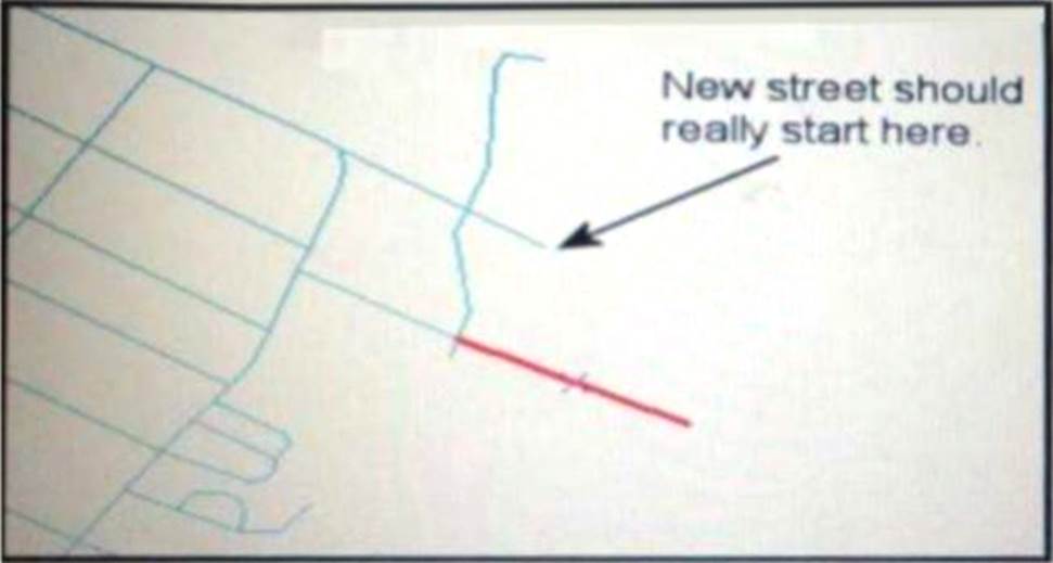
Question No : 4
Refer to the exhibit.
An ArcGIS user added a new street (shown in the exhibit) to a streets feature class within an edit session.
The new street seems to have snapped to an existing street but upon zooming in the ArcGIS user notices that the street is connected to the wrong street.
What is the most likely reason for this error?
정답:
Question No : 5
An analyst has a multi band raster, but needs just one of the bands for a project.
Which geoprocessing tool should be used to extract a single band?
정답:
Question No : 6
In the value for the latitude of origin in a projection tile is modified, making the value less negative (e.g. from -45 to -28).
Which way does the data move?
정답:
Question No : 7
When designing a geometric network where should the feature classes be stored?
정답:
Question No : 8
An ArcGIS user is creating a script tool to automate a common workflow.
Which tool property ensures that the tool only recognizes intended feature data sources?
정답:
Question No : 9
Using the Spatial Analyst IDW (Inverse Distance Weighted) tool an ArcGlS user interpolates a point feature class to a raster. The user notices that some high point values near the edge of the feature class seem to have a dramatic effect on the output.
This occurs even in areas that are far from the high edge values
Which two parameters should the user consider changing in the IDW tool? (Choose two)
정답:
Question No : 10
The ArcGIS user is given data for the Arctic and is asked to perform various types of analysis using the data. The data extends from the North Pole south to 70 degrees North Latitude Data layers may contain points lines, or polygons, and include ice surveys from NOAA depth contours: continental margins, locations of known and suspected oil reserves, endangered species habitat, and territorial boundaries for nations having Arctic coastline.
Which map projection should be used for the data to allow the most accurate buffering of those areas, in order to comply with the U.S court decision that ships may not approach closer than 20 nautical miles to a seal rookery?
정답:
Question No : 11
An ArcGIS user is tasked with converting an IDRISI vector format file to a geodatabase feature class. The user does not need to change any aspects of the data source in the output feature class.
Which tool should the user employ?
정답:
Question No : 12
A taster contains pixels with decimal values.
Which method is used to round raster pixel values to the nearest whole number?
정답:
Question No : 13
An ArcGIS user downloads shapefiles from a Web site. The metadata on the Web site Indicates that the spatial reference the same as that used in the user's workplace, but the downloads draw southwest of the user's data and the downloaded data appears too small.
What is the most likely cause of the alignment problem?
정답:
Question No : 14
Upon opening a model In ModelBuilder. one 01 the tools has a repair icon next to it.
How can the model be repaired?
정답:
Question No : 15
For a project, an ArcGlS user creates a custom user interface form to allow data entry and editing directly with the database. This form must be available within ArcMap and also as a stand-alone tool.
How can this custom form be made available within ArcMap?